


NOAA’s Hurricane Flight Missions Save Lives With Data
The National Oceanic and Atmospheric Administration’s sensor technology improvements and enhanced data collection tools provide crucial forecasting information to better track hurricanes and save lives.

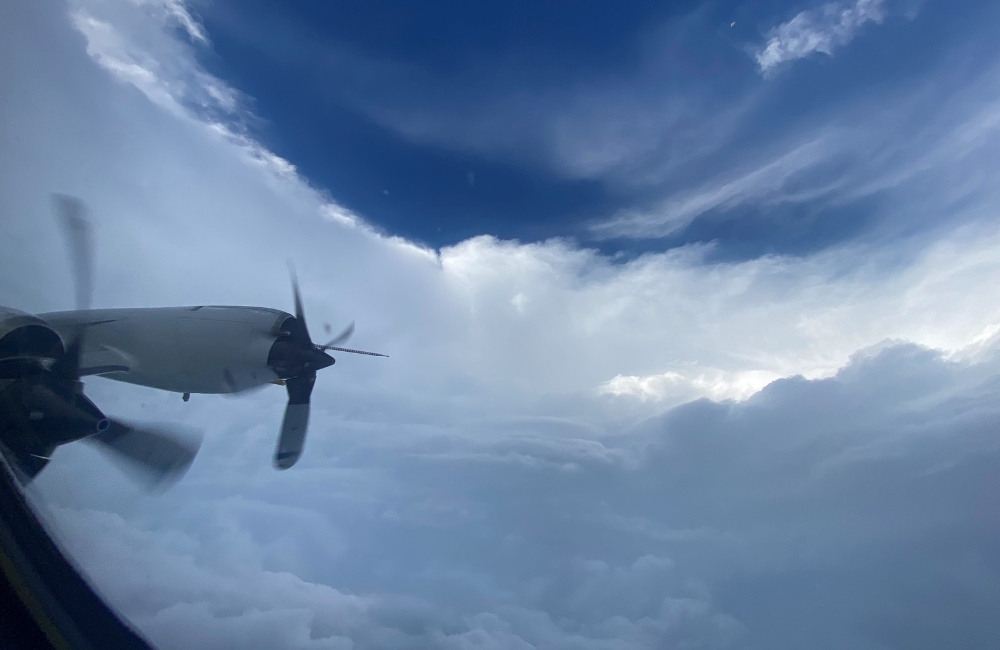
Sensor technology improvements on the National Oceanic and Atmospheric Administration’s (NOAA) two major aircraft are ultimately helping the National Hurricane Center (NHC) keep people out of the path of dangerous storms, such as Hurricane Ian.
The improvements are the culmination of years of improvements to NOAA’s sensors and data-gathering tools on the Gulfstream G-IV-SP and WP-3D Orion, which provide the most accurate information to the NHC as well as the Environmental Monitoring Center and Hurricane Research Division.
The WP-3D Orion’s Tail Doppler Radar (TDR) collects data about wind and moisture fields, which gives forecasters a real-time look at what’s happening inside the hurricane.
Due to these latest developments, NOAA narrowed the storm’s cone of uncertainty by approximately 30% and forecasters now have the ability to predict where a storm will make landfall five to seven days in advance.
Mike Holmes, Flight Director at NOAA’s Aircraft Operations Center, said multiple instruments are mounted to a special aircraft to gather data immediately when the plane flies into the storm. During the eight-to-nine-hour missions, the aircraft also releases expendables called dropwindsondes.
“[Dropwindsondes] are released from the plane at key scientific points like the near the eye of the hurricane and as they descend toward the surface of the ocean they collect temperature, humidity, wind speed direction and pressure and it’s all sent back to the aircraft and we get a vertical trace of all of those parameters,” Holmes said in an interview with GovCIO Media & Research.
Dropwindsondes are released from both the P3 Orion and Gulfstream IV aircraft, but they have very different missions. Dropwindsondes in a P3 mission directly support the questions from the National Hurricane Center.
“We release dropwindsondes at various points in the storm and all of them are received through the Airborne Vertical Atmospheric Profiling Station (AVAPS) system and collected until they splash in the ocean,” Holmes said. “Once they’re in the ocean there is a scientist on board who does a quick Quality Control of the message to make sure its accurate and they transmit it off to be received by the NHC.”
The Gulfstream IV doesn’t fly through the eye of the hurricane, instead, it samples the environment around the storm and characterizes the environment to evaluate how the environment will intensify or weaken the storm or affect its direction.
Holmes said most of this data will go to the Environmental Modeling Center, where their computer models will automatically kick off the next model sequence.
“The whole idea is, better information into the models will produce a better forecast out of the models and then ultimately those models will land in the hands of the national hurricane center forecaster,” Holmes said.
Joe Greene, Chief of Engineering at NOAA’s AOC, said the quality control process is crucial to their mission. Sometimes instruments fail, so there is a person who ensures the dropwindsonde goes out properly and that the information comes back properly.
“The QC process is key because it’s just as important that we eliminate the bad data just as much as to make sure there’s good data going out because bad data will also skew the information,” Greene said in an interview with GovCIO Media & Research. “So, the flight director will look at the data to make sure there is nothing out of place before they let it go off the aircraft.”
NOAA’s aircraft also gather data through active sensors, which send a pulse of energy out into the environment.
“That energy bounces off of a reflector like a raindrop or ice and comes back to our computers and they used it to generate an image that we use to characterize the environment both for science and to mitigate risks,” Holmes said. “There are things that we don’t fly through in hurricanes because it’s too dangerous for the aircraft and crew.”
NOAA also uses passive sensors to collect background radiation not emitted by the aircraft. Another important tool NOAA employs is the Stepped Frequency Microwave Radiometer (SFMR).
“It points down at the ocean and collects background microwave radiation reflecting off the ocean and it turns out there is a relationship between the amount of background-reflected microwave radiation and the windspeed, so as we’re flying over the ocean, we’re mapping the surface windspeed the entire time,” Holmes said.
Once all of the data has been gathered, it’s packaged up at different intervals and transmitted to the Global Telecommunications System before it’s distributed to NHC.
“Ultimately, it’s used in real-time as we’re flying through storms to increase the accuracy of the track and intensity forecast. If the storms approach the U.S. coastline, it’s also used for storm surge and wind forecasts,” Holmes said. “The end goal is to provide an accurate forecast to the general public and if they’re at risk, issue an evacuation warning and get them out of harm’s way.”
Dropwindsondes are a vital part of NOAA’s data-gathering process, but the Tail Doppler Radar (TDR) is just as critical.
“Having an airborne radar that can fly through a storm is a very important thing that you can’t do from anywhere else but in the storm,” Greene said. “We have developed the technology for the tail doppler radar for the aircraft in house, all of the software and all of the interface to the TDR is developed by our engineers.”
According to Greene, the TDR paints the reflectors of precipitation to the left, to the right, above and below of the aircraft. It provides a CT scan of the weather environment, and then that data is sent to the Environmental Modeling Center (EMC) for model initialization.
“TDR data is unique in the sense that not only can it characterize the precipitation, but it can also characterize the vertical winds and horizontal winds. Vertical winds are the real key component that other data sources can’t really generate at all,” Greene said.
For Holmes and Greene, they do what they do to keep people safe. They also encourage everyone to listen to their local leaders and if a hurricane warning is issued, evacuate the area immediately.
“We have a big group of professionals that take things very seriously. We know the importance of our jobs, as engineers we’re not just cranking out widgets in a factory somewhere,” Greene said. “We actually have a positive effect on people if they pay attention to what the forecast is doing. It’s important for us to know at the end of the day we’re doing something that’s very beneficial to people.”
This is a carousel with manually rotating slides. Use Next and Previous buttons to navigate or jump to a slide with the slide dots

-

Cyber Resilience and Recovery Amid Evolving Cyber Threats
Data durability is a key aspect of NIST’s cybersecurity framework for public and private organizations.
21m listen -
Energy Researchers Aim For Holistic Approach to AI Issues
A new center at the Oak Ridge National Laboratory is looking at under-researched areas of AI to better understand how to secure it.
2m read -

How Agencies are Upskilling the Workforce in AI
Federal officials are putting in place new training and education methods to ensure its overall workforce understands the technology.
3m read -

Building Better Data Governance Across FDA
The agency is using emerging technology to tackle its data challenges.
19m listen