


How Geospatial Imaging and IT Inform FEMA’s Disaster Response
FEMA leverages geospatial imaging and IT-enabled machine learning to help predict hurricane landfall, assess storm damage and enable quicker disaster response.

Geospatial imaging provides enormous insight into where hurricanes will hit and the amount of damage they cause, helping the Federal Emergency Management Agency (FEMA) prioritize which communities need immediate assistance.
USA Structures, which is pre-landfall imagery derived data, gives FEMA information about “built areas,” which are zones with critical infrastructure vulnerable to storm damage. The images provide FEMA with a geospatial layer depicting all structures larger than 400 square feet.
“The dataset is attributed with building occupancy type and other key information, that, when incorporated into exposure and impact models, can indicate the numbers and types of structures likely to be impacted within the area of concern,” FEMA officials told GovCIO Media & Research in an email. “Pre-landfall imagery also allows analysts to rapidly detect changes and damages caused by the hurricane or resulting from secondary hazards such as tornadoes and damage-induced fires.”
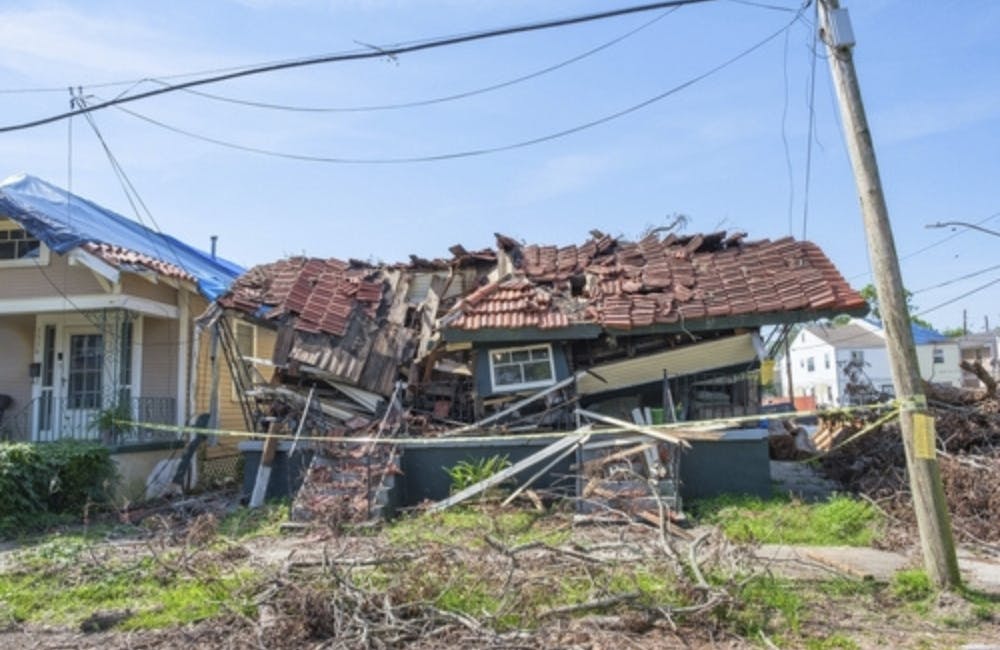
Geospatial imaging also plays a major role in executing FEMA’s mission response once a hurricane hits. During the disaster recovery process, the agency utilizes imagery-derived Geospatial Damage Assessments to speed up emergency assistance to storm survivors.
Pre- and post-disaster aerial imagery offers critical situational awareness and decision advantage to FEMA’s headquarters, Regional Response Directorates and National and Regional Response Coordination Centers.
“High resolution aerial imagery is used to help validate or refute impact and consequence models to rapidly assess the size, scope, character of the disaster and to inform a multitude of decisions such as where to prioritize resources.” FEMA officials said. “It’s also used to deploy field teams like Urban Search and Rescue Task Forces, Disaster Survivor Assistance Teams or where to locate disaster survivor registration intake centers.”
Within 72 hours of a disaster, rapid geospatial damage assessments give an initial assessment of how many damaged buildings are in the disaster-impacted areas and the severity of the damage.
“These geospatial damage assessments not only inform response-oriented decisions, but provide a basis for more detailed assessments and/or field operations conducted by FEMA recovery programs such as, individual assistance and public assistance inspections teams, and may even impact financial grants decisions,” according to FEMA.
Technology also helps FEMA pinpoint where to deliver supplies during time-sensitive missions.
“Pre-landfall exposure and impact modeling can inform FEMA decision makers, before landfall, about areas where there might be a high probability of damages, a high degree of social vulnerability or need among exposed populations, or a high concentration of critical infrastructure or facilities that underpin essential community lifelines, any of which could potentially require the rapid and focused delivery of essential supplies or services,” FEMA officials said.
Machine learning boosts FEMA’s ability to collect, process and distribute aerial and satellite imagery. Information technology (IT) and geospatial modeling software help FEMA assess likely areas of impact where satellite and aerial imagery will be required, as well as plan for and convey satellite and aerial imagery “areas of interest” to data providers so they can collect necessary data.
“FEMA leverages advanced imaging sensors and associated technologies such as Synthetic Aperture RADAR and Multi-spectral imagery and employs IT-enabled machine learning and computer-assisted algorithms and geo-processing tools and indices,” FEMA officials said. “They identify features and elements of interest within the imagery and extract them as geospatially-referenced data points and products that can be consumed by GIS software and integrated with other geospatially-reference data, thereby providing insights and decision support.”
Overall, imaging has been essential to FEMA in its collaborative efforts during hurricane response operations.
FEMA often partners with federal, state, local, tribal, and territorial leaders along with the private sector, including the National and Regional Response Coordination Centers as well as Unified Coordination Groups and Joint Field Offices.
FEMA usually assigns various federal partners to collect high-resolution aerial imagery. They also leverage imagery collected by other federal agencies for agency-specific mission support.
“FEMA will employ the Economies Act and its relationship with the National Geospatial-Intelligence Agency for commercial satellite imagery collections,” FEMA officials said. “When possible, we contract with industry partners for commercial remotely sensed data collection or consume their data if freely shared with our agency.”
This is a carousel with manually rotating slides. Use Next and Previous buttons to navigate or jump to a slide with the slide dots

-

Energy Researchers Aim For Holistic Approach to AI Issues
A new center at the Oak Ridge National Laboratory is looking at under-researched areas of AI to better understand how to secure it.
2m read -

How Agencies are Upskilling the Workforce in AI
Federal officials are putting in place new training and education methods to ensure its overall workforce understands the technology.
3m read -

Building Better Data Governance Across FDA
The agency is using emerging technology to tackle its data challenges.
19m listen -

Strategies for Effective Data Modernization
Data is the lifeblood of critical decisions and streamlines operations across the government, but many agencies struggle with inconsistent standards.
33m watch


